Cal Fire Maps New High-Risk Zones Along Mattole Corridor
Cal Fire's updated fire hazard severity zone maps reclassify 14,200 acres along the Mattole corridor from moderate to high or very high risk, with significant implications for building permits and property insurance.
Cal Fire released updated fire hazard severity zone (FHSZ) maps for Humboldt County this week, and the Mattole corridor took the biggest hit. Approximately 14,200 acres between Honeydew and Petrolia have been reclassified from moderate hazard to either high or very high hazard, affecting an estimated 340 properties.
The reclassifications are part of a statewide FHSZ update that Cal Fire began in 2022, using revised modeling that incorporates ember transport distances, slope-adjusted flame lengths, and vegetation condition data derived from 2024 LANDSAT imagery. Humboldt County’s updated maps were among the last in the state to be finalized.
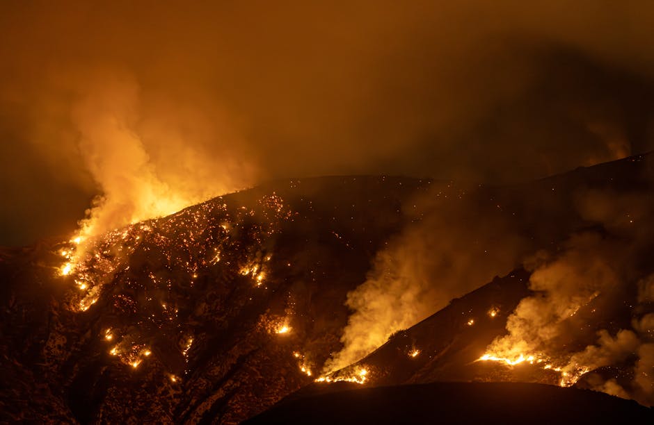
The Mattole corridor’s reclassification was not unexpected. The area’s combination of steep terrain (slopes averaging 35% to 55% along the river canyon), dense mixed-conifer and tan oak understory, and limited road access for fire suppression equipment has long made it one of the most fire-vulnerable landscapes in Humboldt County.
What’s new is the data backing it up.
The modeling
Cal Fire’s revised FHSZ methodology uses a 20-meter resolution fuel model rather than the previous 30-meter model, capturing fine-scale vegetation patterns that older maps missed. The updated analysis also incorporates fire weather data from the past 15 years, including the 2020 August Complex Fire (the state’s largest recorded fire at 1.03 million acres) and the 2023 fire season, which burned 56,000 acres in Humboldt and Trinity counties combined.
For the Mattole corridor specifically, the model identified three factors driving the reclassification. First, vegetation density: post-drought die-off of tan oaks between 2020 and 2023 created a standing dead fuel load of approximately 12 tons per acre in the worst areas, well above the 8-ton threshold that Cal Fire uses for very high severity classification.
Second, fire weather exposure. The Mattole Valley’s east-west orientation channels offshore wind events directly up the canyon. Cal Fire’s historical fire weather data shows that the corridor experiences red flag conditions (sustained winds above 25 mph, relative humidity below 15%) an average of 11 days per year, compared to the county average of 6 days.
Third, access. The Mattole Road, the primary (and in most places only) paved road serving the corridor, is a narrow, winding two-lane route with limited shoulders and no alternate evacuation routes for most of its 62-mile length from Ferndale to the coast. Fire suppression response times from the nearest Cal Fire station in Garberville average 45 to 55 minutes.
Impact on residents
The practical consequences of reclassification are significant. Properties in very high FHSZ zones face stricter building code requirements under the California Building Standards Code, Chapter 7A. New construction and major remodels must incorporate fire-resistant roofing, exterior walls with a one-hour fire rating, dual-pane tempered glass windows, and a minimum 100-foot defensible space zone.
For existing properties, no retroactive building code requirements apply. But insurance is another matter.
California’s FAIR Plan, the insurer of last resort for properties that can’t obtain coverage on the private market, has seen enrollment spike in fire-prone rural areas statewide. In Humboldt County, FAIR Plan policies increased from 412 in 2023 to 687 in 2025. The Mattole reclassification is expected to push that number higher.
“My insurance company dropped me in November,” said Lori Nakamura, who owns a 40-acre property near Honeydew. “They said the fire risk was too high. This was before the new maps even came out. Now with the reclassification, I’m looking at FAIR Plan rates that are double what I was paying.”
FAIR Plan premiums for rural Humboldt properties average $3,400 to $5,200 annually, compared to $1,200 to $2,100 for standard market coverage.
Community preparedness
The Mattole Restoration Council, a nonprofit that has traditionally focused on watershed and salmon habitat restoration, has expanded into fire preparedness work over the past three years. The organization runs a volunteer chipper program that has treated defensible space on 86 properties since 2023 and maintains a community fuel break along a 2.3-mile stretch of Mattole Road near Petrolia.
“We’re a fire community now, whether we wanted to be or not,” said MRC executive director Sungnome Madrone. “People here have always dealt with fire. But the risk profile is changing. The fuels are heavier, the fire weather windows are longer, and the insurance market is telling us something we need to listen to.”
Cal Fire Battalion Chief Robert Tanaka (Humboldt-Del Norte Unit) said the agency plans to hold a public information session on the new maps in Petrolia in April. He encouraged property owners in the reclassified zones to request a free defensible space inspection through Cal Fire’s website.
“These maps aren’t meant to alarm people,” Tanaka said. “They’re meant to inform decisions. If you’re in a very high zone, that doesn’t mean your house is going to burn. It means the conditions for a serious fire are present, and you should plan accordingly.”
The updated maps take effect July 1. Property owners can submit formal objections to the reclassification through Cal Fire’s public review process, which closes April 30.